Showing posts with label bicycle. Show all posts

Wednesday, April 20, 2011

Trip to Manchester, VT

Yesterday, Jeannine and I met some friends (old friends for her, new friends for me) at the Northshire Bookstore in Manchester, VT. The Northshire is perhaps our favorite bookstore -- I highly recommend it to anyone who loves books (and good food -- they have a very nice cafe). And Manchester is kind of a neat little town -- a slightly odd but charming combination of historic places (perhaps the most prominent being "Hildene", the estate of one of Abraham Lincoln's sons), and modern outlet stores. There is also the beautiful Mount Equinox, the top of which can be reached by an automobile access road (just be sure to take the advice of the signs posted on the access road, and stop halfway down for a few minutes to let your brakes cool down -- the last time we took that trip, I didn't do it, and my car's brake discs -- or probably more likely the brake pads -- were smoking when we got to the bottom).

On this visit to the Northshire Bookstore, I knew Jeannine would be occupied with writing in the bookstore's cafe for several hours, so I decided I would try to see if there were any interesting places to bicycle in the surrounding area. And at www.traillink.com, I found the Delaware and Hudson Rail Trail, a 22.3 mile trail near  the New York border. A rough estimate from looking at the map indicated that it was probably between 10 and 20 miles from Manchester, so that certainly seemed within the realm of practicality and scheduling.

So I hauled a couple of bikes along with us in my truck (just in case one of the friends wanted to join me) and while Jeannine was sipping coffee and turning words into art, I drove over the mountains toward West Rupert, VT, where one of the parking areas for the rail trail was supposed to be found. It was interesting to see that there was still quite a bit of snow up in those hills. Fortunately, none of it remained down at rail trail altitude.

I found the parking spot with no problem, got out my bike, and headed south. I was a little disappointed at first that the trail was not paved (I have gotten a little spoiled, I guess, by the plethora of paved rail trails in our area), but the cinder path surface was actually not bad to ride on… a little bumpy and ragged in spots, but nothing I wouldn't ride on again. 


To the right of the trail, a small river meandered in and out of the fields and trees.


I only rode for out forty-five minutes, given that there was rain predicted, but in that short time I decided that I need to come back to this trail when the weather is nicer and the greenery which gave the "Green Mountain State" that name is out in profusion -- it should be quite beautiful.


Near where I decided to turn around, I saw this view in the small river which followed the trail most of the way:


There's something about that blue green color of turbulent water in the rivers around here… I find it mesmerizing.

I saw no other bicyclists on the path, and only one other person, a man walking his dogs. On the drive back to Manchester, I stopped in a small town called Dorset, because I saw something that caught my eye -- right next to the road, huge blocks of marble and what appeared at first to be a pond surrounded by marble blocks.

But, in fact, it was something else, something illuminated by this sign:

"FIRST MARBLE QUARRY


Oldest Quarry in U.S. 1785


Here, near Mt. Aeolus, Isaac Underhill opened the first marble quarry in 1785. Dorset quarries were most active in early 1800's when small slabs were used for hearths, doorsills and headstones. With better transportation and saw, larger blocks were quarried."

It was odd -- but cool -- that this marble quarry would be literally just a few feet off of a main road in this part of Vermont. I parked the truck and got out to take some photos. 

Here's a small panoramic view of the quarry -- you can see the road, Route 30, I believe, on the right hand side.


I really liked the look of this stack of marble blocks.


I walked to the quarry's edge and stared down into the water… and wondered exactly how deep it was. I felt an irrational pull (easily resisted, I hasten to add) to dive in. As I stood there, I couldn't help thinking of the "… lovely, dark, and deep…" phrase from Robert Frost's "Stopping by Woods on a Snowy Evening" poem.


This shot I like for the rippling reflections, and the "marble lagoon" look of the place…


 I would have taken even more, and spent more time wandering around there and checking out all the interesting stacks and heaps of gargantuan marble blocks and slabs, but for the fact that there didn't seem to be any LEGAL parking spots near the quarry, which was more than a little odd, given that it was a public attraction. 

I continued on back to Manchester, joined Jeannine to say farewell to our friends (one of whom, a four year-old girl, drew a nifty turtle -- not a ninja turtle -- 


...for me before she left with her parents), and then headed home. On the way out of Manchester and heading toward Bennington, we debated what to do for dinner -- should we continue south on Route 7, the way we'd driven up to Manchester, and stop in Williamstown to eat at my favorite Mexican restaurant, Deperados… or take Route 9 east out of Bennington, and head towards Brattleboro, where we could pick up some yummy deli items at the Vermont Deli, another of our favorite food spots? We opted for the latter.

I wish we had taken our own advice -- just after turning onto Route 9, we were musing that it would probably be a good idea to call the Vermont Deli to make sure that they would be open when we got there. They WOULD have been open -- we got there around 5:30 and their posted hours said they closed at 7 -- but THAT day, of all days, they were closed for "Spring Cleaning"! 

Oh well… "the best laid meal plans" and all that. Even so, it was a fun day. -- PL

Sunday, April 17, 2011

Paint and Pixel Festival

Yesterday wasn't the most promising of days for bicycle riding -- kind of chilly, with predictions of serious rain. But I went out anyway, on my favorite bike, leaving from the MIrage offices and heading out to see if my favorite loop was free from flooding.

First, though, I had a stop to make -- at the "Paint and Pixel Festival" put on by "Runners" artist Sean Wang and his wife, Peggy (although, according to Sean, Peggy was the person most responsible for organizing the event). It was being held in the Old School Commons in the center of Northampton, and many local artists were going to be there, including some of my Mirage pals -- Mike Dooney, Jim Lawson, and Dan Berger. Here's a photo of Dan and his wife Jess (Jim Lawson was sitting at the table to their left, but I guess he'd stepped out at that moment).


Mike Dooney was set up right behind Dan, and next to mecha artist Dave White.


And here's a reverse view of that scene...


I got there about an hour after the event had begun, and it looked to me like it was already a success. The modest-sized exhibitor's hall was busy, with lots of people wandering around talking to the various artists and looking at the wide range of small press comics, books, prints, posters, and original art that those artists had for sale. Here are a few random photos of the hall and various exhibitors. 


I tried to get photos which could be stitched into panoramic shots, but there were enough people moving around that I was only able to do this one.


Overall, the show kind of reminded me of a few of the small comics conventions I'd been to years ago -- it had that friendly vibe, but without all the tables full of old comics. If I am invited to the next one, I will very likely go.

Here's a shot of Peggy and Sean near Sean's table, with his "Runners" comics.


I chatted for a few minutes with local illustrator and writer Diane De Groat, shown here explaining to me her technique of combining Photoshop and traditional painting techniques in her charming picture book "Dogs Don't Brush Their Teeth".


One of the people I wanted to talk to was Howard Cruse -- he's the guy in this photograph with the glasses and t-shirt -- whose "Stuck Rubber Baby" book I really admire. But I forgot to stop at his table! D'oh! At least I got this photo.


After hanging out at the "Paint and Pixel Festival" for about half an hour, I took off again on my bicycle, but sadly didn't get far -- Pynchon Meadow Road was flooded, as you can see in this little panorama:


I put red dots in the middle so you can see where I SHOULD have been able to ride through, had the river on the right side of this image not overflowed its banks. Hopefully, the water will go down soon and the way will once again be clear (and dry).

I didn't get much of a ride that day, but enough to satisfy me. And I did take the opportunity afforded by a more open schedule (one without a longer bike ride) to go back to the "Paint and Pixel Festival", this time to bring a couple of boxes of cookies from the Normand Bakery in Northampton (for the exhibiting artists). I had a specific goal in mind for this second visit (besides delivering sweets) -- I wanted to see if I could talk to the painter and children's book illustrator Ruth Sanderson, who was actually working on one of her paintings at the show, a new cover for a twentieth anniversary edition of her "Twelve Dancing Princesses" picture book.


And I did have a nice chat with her, and got a closeup look at her work on this new painting. She is REALLY good. "Mike Dooney good", one might say. (Which I consider to be a compliment to BOTH of them.)


Although I only experienced a small slice of the whole inaugural "Paint and Pixel Festival", I think it is safe to say that Peggy and Sean should be congratulated for putting together a really nice show. I hope it continues. - PL

Wednesday, October 27, 2010

Weekend in New Hampshire (and Maine)

This past weekend, my wife went out to Minneapolis to visit a family friend and attend a convention of like-minded bloggers. I would have loved to have gone with her, but in spite of my best efforts, it just didn't work out. So while she was in the midwest having fun, I decided that rather than be miserable and lonely at home, I could be miserable and lonely* somewhere more interesting and potentially distracting in a good way. So I chose to spend those days by myself in the Dover, NH area.
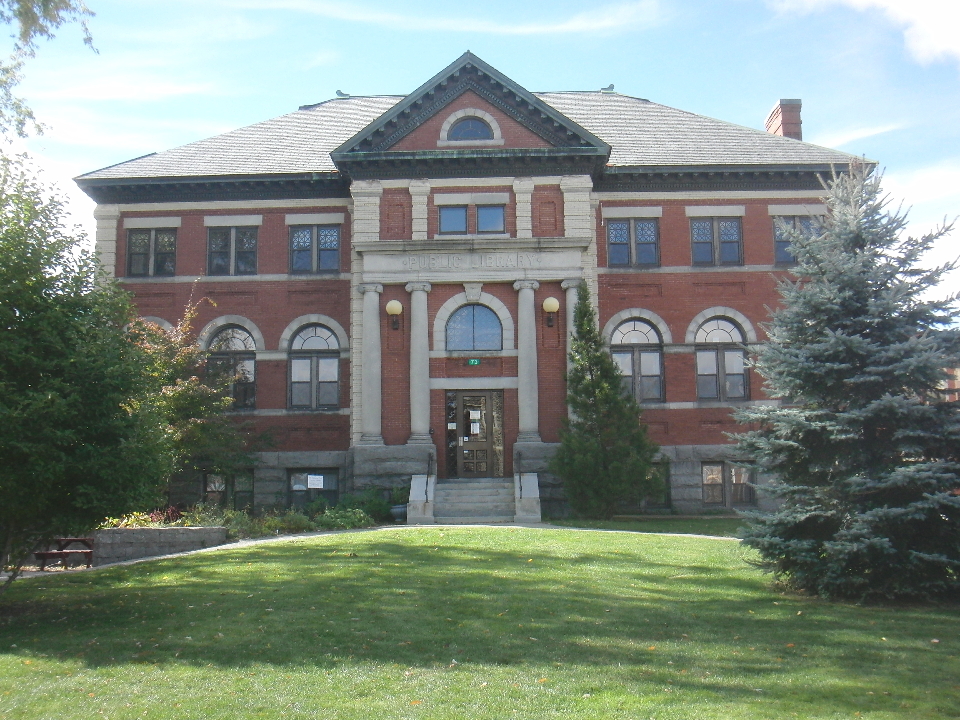
I stayed in Portsmouth, but I made trips to some of our our old haunts, favorite areas on the seacoast as well as Dover itself and the neighboring town of Durham. It was interesting to walk around Dover and see what has changed -- not much, I think. The ice cream parlor that we used to enjoy going to is no longer there, replaced by a nifty little cafe where I ate two of my lunches that weekend, and they were both excellent. I walked over to the good ol' Dover Public Library, which we used quite a bit when we lived there…


… and when I went inside to poke around, I was happy to see that they still had the "magazine swap" shelf that I so enjoyed back in the early 1980's -- it was a great way to recycle your old magazines. (Although i think it may have been called a magazine EXCHANGE back then… but I could be confusing it with a similar thing at the Sharon, CT library some time later.)


Looking around the library, I found Jeannine's latest book, "Borrowed Names", shelved in the poetry for young adults section. That's it, fourth from the left.


Here's a shot of the cover of "Borrowed Names".


(By the way -- and I say this in a completely unbiased way -- it's a great book. Check it out!)


Continuing my stroll around Dover, I took one street that led to this view…


… a bit of interesting scenery I don't recall from our days in Dover. Maybe we never walked up that street.

After a couple of hours of reminiscing, I drove out to Ogunquit, ME, where I walked on part of the fabled "Marginal Way", and I was reminded of why I prefer the coast of Maine to the coast of Cape Cod (well, to be fair, the parts of the coast of Cape Cod that I saw a couple of weeks ago)...


... great rocks! You can't really see it in the photo below, but the stiff breeze was blowing spray off the white-capped waves -- very dramatic!


I did sit down and do a little sketching of some of the rocks, but it was pretty cold and breezy, so I only did one drawing. I have to spend more time up there in the warm parts of the year, I think.

The next day I decided to take a drive up to one of our favorite beaches, Long Sands in York… so named because it's, well, a long, sandy beach. I remembered that the last time we walked on it,  the sand was not very squishy underfoot, but firm… and I started thinking that MAYBE it would be firm enough to support me and my bicycle. So I parked near one end of the beach, carried my bike down the steps to the sand, and started riding. And it was GREAT! I think -- no, I KNOW -- that this was the most fun I had all weekend. I spent probably an hour riding up and down the beach, dodging seagulls and sandpipers, going in and out of the surf, and watching my shadow, cast by the setting sun.


It was almost too picturesque, and shortly made even MORE so by the rising of the moon just off Nubble Point near the lighthouse. I took a few photos of this scene using the zoom lens on my camera (which is why the moon looks so huge, I think), and put them together into this little panorama.


On my last day of this impromptu vacation, I headed up a little further into Maine, to drop in unannounced on Steve Lavigne and his family. I think I surprised the heck out of him, but we had a nice visit. Then I decided to drive back to Dover one last time, because i had a mission there.

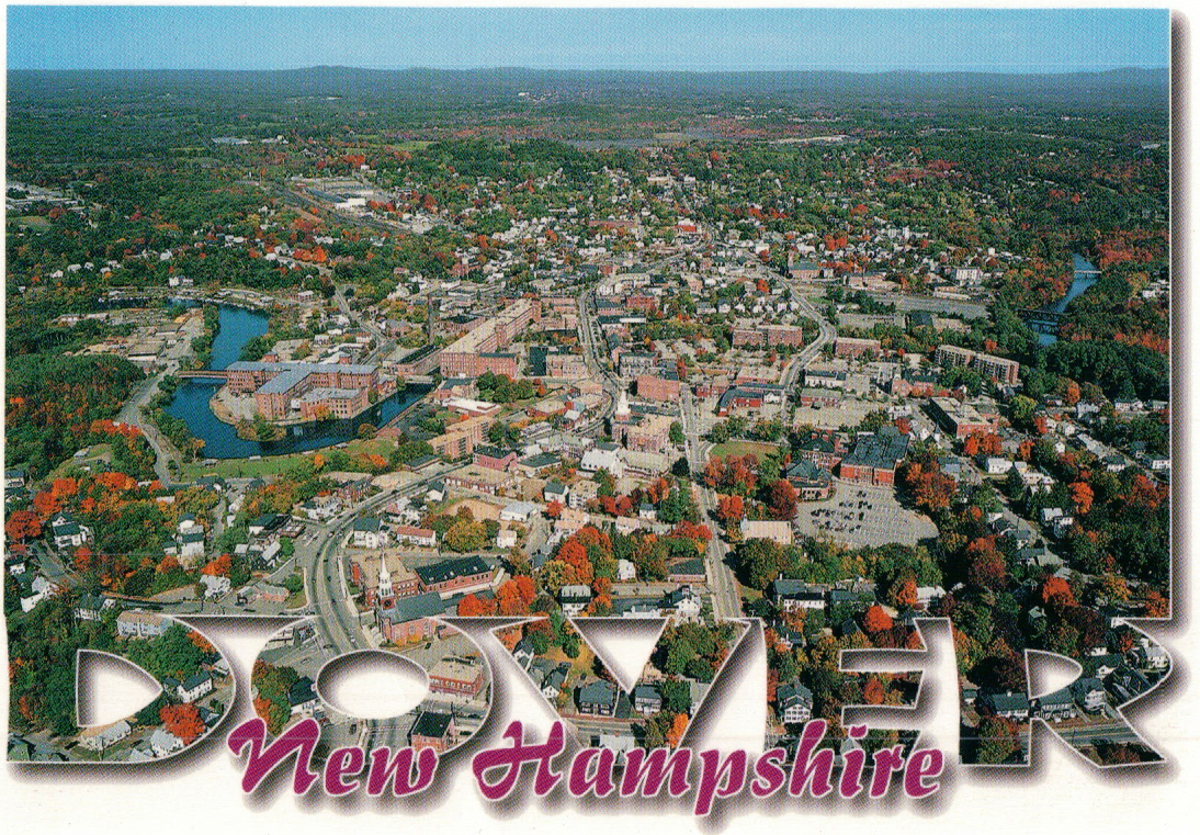
You see, on my way up on Friday, I had stopped at a general store called Calef's just outside Dover, and picked up a few postcards which I intended to mail to Jeannine. One of them featured a cool aerial photo of Dover, and I was hoping to see if our old house was, by some chance, included in the image. So I was studying it, and for some reason, I just couldn't figure out exactly from which direction the photo was taken… which was a little odd, because I am pretty familiar with the layout of downtown Dover. So I once again walked around the streets of Dover, trying to pick out significant landmarks and compare them to the tiny images in the postcard, attempting to get my bearings.


And after about ten minutes of this, it hit me -- the photo was REVERSED! I found it kind of surprising that just reversing the image would throw me off so much, but it did. (When I got home, I scanned the postcard, flipped in in Photoshop, and instantly everything fell into place and made sense.) Sadly, our old neighborhood was just out of shot in the postcard's aerial image.


On the drive back home, I decided to take a spin through nearby Durham, NH, and had to stop to take a photo of this fabulous tree, which just at the moment I was driving by happened to be lit up perfectly by the sun. It was simply blazing. -- PL


(*Full disclosure: I was not actually miserable. -- PL)

Friday, October 15, 2010

Back from the Cape

I am back from my first trip ever to Cape Cod… something that probably strikes those who know I have been a resident of Massachusetts for fifty-two of my fifty-six years as somewhat odd. Although my wife has been there a number of times, I just never got around to it. I'm not sure why. Perhaps some of it had to do with the horror stories I'd been told by various friends and family about the awful traffic jams and big crowds of tourists in the summer months.

In any event, this past month Jeannine and I decided to go there together, and I found us an inn in Harwich Port with a room which had a great view of the ocean.


We deliberately did it this month, which is the off-season for the Cape… and it really is. I was somewhat shocked by how many place weren't open. But it was also kind of nice to not have to bump elbows with crowds of vacationers, and just walk into restaurants without making any reservations.

Jeannine really wanted me to get a chance to ride on the bike trails out on the Cape -- she'd done a little of that and thought it was great fun. So we put the bikes in the back of the truck and went to several spots along the Cape Cod National Seashore, including the dunes out in Provincetown.


The rides were fun, but I have to say that I didn't really love the up and down nature of the Provincetown bike paths. These were the ones which I had heard about from other bicyclists as being the most awesome, beautiful paths they'd ever ridden on. The image I'd thus developed in my mind's eye proved to be more interesting than what I actually saw. In fact, there was only one stretch of the path, on the last part of the ride we did out there, coming up to the Visitors' Center, which came close to what I imagined these paths to be. And I will admit, that stretch was spectacular.

But for the rest of it, probably about 75% of the time we could have been riding on almost any bike path in the state, as it wound through fairly dense forest. We did see several lovely ponds (something the Cape has in abundance), and there were some neat views of the sandy dunes with their scrub pine trees and dune grass.

But I think the thing that I liked least was the very hilly nature of these paths. I will concede that we probably got a better aerobic workout than we usually do on the more level bike paths we tend to ride on, but I like the fact that on those more mellow paths you can view the scenery much more easily. On a lot of the sections of the Provincetown paths, we were either struggling to get up hills or careening down them at high speeds, and neither was really conducive to sightseeing.

All that being said, I think I might like to go back there and ride them again now that I know what to expect… and what NOT to expect. And there are a lot more miles of trails to be ridden. We found one section in Harwich, near where we were staying, and rode a good stretch of that, seeing more beautiful ponds and some cranberry bogs along the way. It was more like the paths in this part of the state, which we liked (except we don't have any cranberry bogs out here in western Massachusetts).

We also walked up to the top of the Pilgrim Tower in Provincetown, which got our hearts pumping (600 steps to the top, I think it was).


The views from the top were great -- you could see pretty much all of Provincetown.


We lucked out weather-wise -- I had seen rain predicted for two of our three days there, but each day was beautiful -- sunny and cool, but not cold -- until this morning, when what we were told was a "Nor'Easter" hit the area. We'd heard rain last night, and woke up to some stiff breezes, but it didn't seem very bad, as storms go.

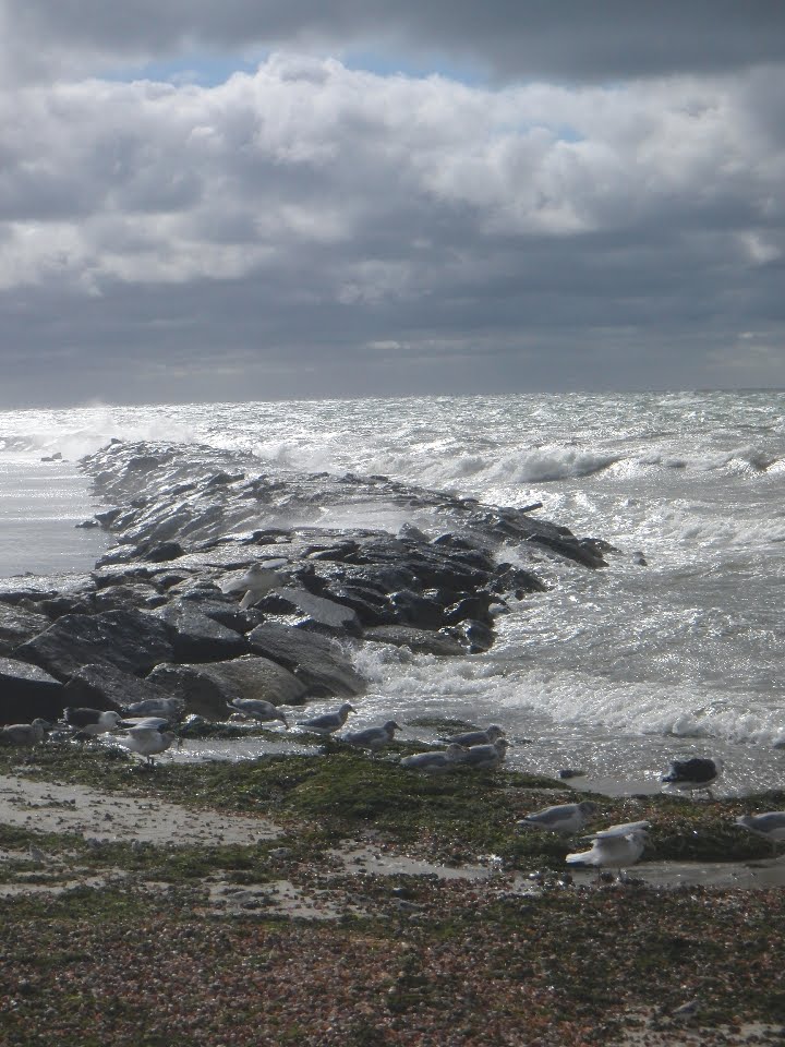
Well… the last walk on the beach we took before jumping in the truck and driving home turned out to be… interesting. We walked first about half a mile down the beach WITH the wind, then turned around and walked back AGAINST the wind… and I'm glad we didn't have to walk much further. I think it was partly that the breeze on the beach was more intense, coming in off the ocean with nothing to break it up. We were definitely leaning into it to get back to the truck. Here's a photo I took during that stroll/slog of a breakwater near our inn, with storm-tossed water... uh... breaking over it.


All in all, it was a fun three days of vacation. I'm glad I finally got to see the Cape, and now I can say that I have been from one end of Massachusetts to the other. It was, of course, great spending this quality time with my wife, and being near the ocean (even though I prefer the more interesting rockier coasts of Maine and New Hampshire) is always a pleasure. We'll probably go back some time in the relatively near future. -- PL

Saturday, March 20, 2010

It's Spring! (almost...)

This Thursday, for our regular weekly meeting, my friends Rick and Rob and I decided to drive out to Pittsfield, hauling the bicycles in my truck, so that we cold take our inaugural 2010 ride on the Ashuwillticook Rail Trail which goes from Pittsfield to Adams. It was a beautiful sunny day, and we were very much looing forwad to this ride. I fully expected that the bike path would be clear of snow and ice, as the trail between Northampton and Amherst has been for several weeks, and Pittsfield (or so I had always thought) had more or less the same climate as the Northampton area. Rick kept telling me that it would be colder out there, and I didn't believe him.

So off we went down the trail, grooving on the sun and sky and the wide-open trail. I snapped this photo of Rob and Rick shortly after we started riding -- I think there's a kind of "Easy Rider"/Dennis Hopper and Peter Fonda vibe to it.


My first clue that I might be wrong about the climate difference could have been this still half-frozen lake along the first part of the bike trail on the Pittsfield end.


ABout two-thirds of the way down the trail, after having to skirt a few tiny snowy patches along the way (no big deal), we were confronted by a section of the trail COVERED in snow and ice. Rob voluteered to jog down the trail a bit to see if this was just a small aberration -- here's a photo of Rick waiting for him.


Rob came back with the bad news the as far as he could see, the trail continued to be covered by the slippery stuff. (I should note that this part of the trail is the shadiest section of its entire length, which is nice in the heat of the summer, but apparently not so great for the melting of snow and ice in the spring.)

So we decided to turn back, and didn't make it all the way to the center of Adams as we had planned. Bummer. But it was still a very nice ride, and we got to have a meal at Ozzie's, one of my favorite restaurants, so it was definitely not a total loss. -- PL

Thursday, September 17, 2009

My bicycling misadventure

This past Saturday, I had decided to go for a bicycle ride, even though the weather wasn't that great -- a slight mist in the air, overcast, but actually not too cold (about 65 degrees). I got the recumbent out and headed out toward the dirt road loop I've been doing past the bird sanctuary on Old Springfield Road. I went a little further and headed up towards the Audubon Center, taking the right hand of the fork in the road just past their entrance drive. I took that road to the end, then headed back.

I stopped to look at an old, unpaved trail that crosses the road I was on, heading north and south, the north end going into the Audubon Center. I'd wondered about this path before, but today it looked more appealing than usual to try to ride on -- like somebody had been clearing it up a little, taking out sticks and maybe chopping back some brush. I decided to take the southern route of the path. Along this path on its left side ran a line of trees. To the left of this line of trees was a small field, with what looked like a well-worn track (probably made by farm tractors or other vehicles driving through it) immediately abutting the tree line. This is an important detail, to which I will later come back.

At first, the riding was fine... a little rough, with some roots and mud, but not too bad. Then, after pedaling in a few tenths of a mile, I saw an appealing path heading off to the left into some pretty fields, and I took it.

For a while, it was fun -- beautiful trees and bushes, small meadows, and the path was more or less clear, though in places it had long grass growing in it. Then the grass and weeds started to grow taller, and the path disappeared.

I continued on, trusting in my sense of direction (which is generally pretty good, or so I thought) to lead me back out to either the original path I had taken or to that track into the field just to the left of the trailhead I had started down originally. I figured I would just make a gentle arc back in that direction, and I would in due time come out in that general vicinity. But the weeds just kept getting taller, and I couldn't see the path. Eventually I couldn't pedal through the weeds any more and I got off and started pushing my bike. That was only slightly easier, as the weeds and grass -- which by this point were easily three or four feet high and dense -- would get caught in the various parts of the bike, making pushing a real chore. Even walking through them was a chore, as they would wrap around my feet, getting me tangled up and making me stumble. I kept going, and thought I saw a way out near the edge of some woods... but although the weeds got thinner there, I was faced with a brook which I had not expected to see. I realized then that I had no real idea where I was -- I was lost. I didn't know where the original path was. I had gotten completely turned around. Looking about me, I could see no recognizable landmarks.

So I decided that the best thing to do was to head back the way I had come in, and retrace my steps back to the original path. I was not looking forward to this, as it meant fighting my way back through the high grass and weeds, and going UPHILL for the most part. I did think that at least I had already been through that stuff, so my path would be a little bit clearer than just bushwhacking through untouched growth. Well, that plan fell apart when I realized I couldn't find my previous path -- I just could not see where I had come through. So this meant I did have to bushwhack.

Around this time I started to realize that my heart rate had gone up quite a bit -- this was the kind of aerobic exercise that I don't generally get, and I could feel my heart pounding very fast. It was then that I think I started to panic. I knew that although I could not be TOO far away from either the path or the paved road -- probably no more than a mile at most -- I had no real idea which way I should head to get to either one of them most quickly. What concerned me was that if I started off in what seemed like a likely direction, I could -- given how completely off-course I was at the moment -- just start walking in circles, getting even more exhausted as I tried to force my way through the tall weeds. I started to worry that I might have a heart attack as I fought my way through the dense growth. I also started to worry that I might run into bears (I know, unlikely... but not impossible... they're pretty common around this area). I looked around and I could see no houses, no roads... just tall weeds and grass and trees. If at that moment I had been asked to point to where the paved road was, the one on which I had ridden to the trailhead, I know now that I could not have done it correctly except by sheer chance. By this time, it was almost impossible to push the bike through the grass and weeds, so dense had they become, so for the most part I had to lift it up and CARRY it, which got my heart rate going even more (it's a long, fairly heavy bike).

I was starting to freak out. No one knew I was out there. If I keeled over from a coronary, I probably wouldn't be found for weeks. The grass and weeds were so high that I don't think the bike could be seen even from a short distance. I actually yelled "Help!" a few times, but got no reply. I came about a minute or two away from calling my friend Rob, who lives in nearby Easthampton, to see if he could come and find me -- maybe park out on the road and beep his horn so I could get my bearings or something. Every couple of minutes I would stop and try to let my rapidly beating heart slow down. Of course, when I'd do that the mosquitos would start to gather.

The one manmade thing I could see about three hundred feet away were some power lines under which I had passed when I was crossing this field of tall grass and weeds previously, before I decided I had to turn around and retrace my steps. But they were an old style of power lines with wooden poles and I couldn't recognize them as something that led to the road I was looking for -- for all I knew, they went off through the surrounding woods and fields until they crossed Route 10, and that was much further than I cared to go (or, perhaps, even COULD go -- my strength might not hold out). But I figured I should try to make my way back to them, and see if there might be an old track that led alongside them. So I fought my way through the tall stuff, and there WAS kind of an almost invisible track -- like it had been cut or crushed down months ago and had almost (but not quite) grown back up as tall as the other weeds and grass. So I started following this.

In spots, I could actually pedal, so I rode a little bit. But for the most part, I got off and pushed. I had to cross a small stream along the way, but that wasn't too bad. Oh, and at some point during this, I noticed that my chain had come off the sprocket, which made me groan -- would I have to fix the bike while simultaneously trying to find my way out of this predicament? Fortunately, I was able to quickly get the chain back onto the sprocket with judicious use of the twist shifter and backpedaling.

My heart was still pounding pretty hard, so I forced myself to take it easy, stopping every so often. But I really wanted to get out of there! Eventually, I came out from behind some trees and saw a house I recognized about a quarter of a mile away. Then I realized where I was... and I was stunned to see that it wasn't anywhere near where I thought I should be. (It was actually at the intersection of the roads near the entrance to the Audubon Center, which is about half a mile back from where I picked up the trail originally.) The field I had to cross to get to the road was, thankfully, recently mowed, so the grass was only about a foot high. I was able to ride about half of the way. Finally I made it to the paved road. What a relief!

A few days later, I went back with my friend Rick to show him the site of my misadventure. I didn't want to have to struggle thorough that high, tangly stuff -- it still gave me the creeps to even think about getting back into that -- so we stuck to the edges of the fields and only went far enough so that I could point out to him where I'd screwed up. Rick had brought with him a few satellite photos he'd printed out from Google Earth, so we were able to use though to get our bearings. And it's a good thing, too, as we rapidly lost track of where we were. At one point, we were standing at the edge of the last field, the one where I had started to panic, and Rick asked me where, from our perspective, the road up to East Street in Easthampton was. I looked around and pointed over to our right. "No," Rick said, and pointed straight ahead. "It's over there." I couldn't believe it, but looking at the Google Earth photos, it was clear that he was right and I was wrong. It was a sobering moment.

Here's a panoramic view of the area in question...


So what's the point of this post? I guess it's just to say that I learned a lesson that day about the dangers of solely depending on my sense of direction, which -- prior to this -- I'd always felt was pretty accurate. It's funny -- about a month or so ago, I was listening to a piece on the radio about a study that was recently done testing people out in the woods, to see if they could find their way without compasses or other sorts of navigation aids. Almost everyone tested -- I think it might have been over ninety percent -- ended up walking in circles. Very few people could walk for any significant distance in a straight line.

And that's what made my little misadventure scary... the idea that while I was really no more than a mile or two from "civilization", I might have continued to walk in circles, all the while thinking that I was heading in a straight line... getting more and more exhausted and panicky as I went. -- PL

Sunday, August 2, 2009

Water crossing

Western Massachusetts has seen an unusual amount of rain this summer, and a few days ago we had yet another big storm. I went out the next day for a bicycle ride, down Old Springfield Road, and ran into this:


The Connecticut River, which you can't see in this photo but which is off to the left of this scene by a few dozen feet, had risen enough so that it flooded this portion of the normally dry road... resulting in this stretch of water I'd estimate as being about 150 feet long. I debated whether or not I should try to ride through it, but decided against it for a couple of reasons -- one, I was going for a motorcycle ride later and didn't want to get my shoes soaked, and two, I really didn't know how deep it was out in the middle of this thing. What you may not be able to see further ahead -- about two thirds of the way across this flooded area -- is a pretty strong current of water flowing from left to right. I was a bit concerned that I might get out there and end up soaking a lot more than my shoes. So I passed on this little adventure.

But it reminded me of a similar occurrence from a few years back, when I was riding one of my recumbent bicycles on this same road but on a stretch about another half mile on. The river had at that time risen and flooded parts of the road... but that day I was wearing my water sandals, and decided to go for it. I was also carrying my camera in my left hand (I do most of my shifting on the bicycle with my right) and took the following video of my journey across the waters. I can't say exactly how deep it was, but at one point you will hear me say something like "It feels nice on my feet" -- referring to the water, in which, at that point, while pedaling, my feet were submerged.


I've tried this kind of thing a few times, and it doesn't always work as well as it did here -- I remember one time I got halfway across and a floating stick jammed itself in my chain, derailing it and stranding me in the deepest part, from which I had to push the bike to dry land to fix the chain.

But this time, it went smoothly, and was a lot of fun. And I didn't drop the camera in the water. -- PL

Saturday, April 18, 2009

Two bike trips

With the warm weather finally, grudgingly arriving, it's been fun getting out on the bicycle again, without having to bundle up so much that it makes pedaling a pain. I usually do my rides on the paved bike path between Northampton and Florence or Northampton and Amherst, but this week I got off the path.

Thursday I rode with my friends Rick and Rob out to a new lunch place called Barstow's on Route 47 heading towards South Hadley. It's a nice joint with great sandwiches and fresh-baked goodies. Here's a view (incorporating Rob) from their outdoor dining area, looking west toward the Connecticut River (which I don't think you can see in this image, but it's really just about a half mile away).


Then on Friday I took another ride with Rick, this time from Northampton over to Easthampton (coincidentally, to have lunch with Rob again). We took the back way on the dirt road which runs past the bird sanctuary. It can be a beautiful ride, with great scenery, even now when the trees are still pretty much bare of foliage. Unfortunately, there are a number of idiots who think it's a good idea to drive down this road and dump some of their trash along the way. I've see stuffed chairs, mattresses, couches -- even a DVD player. On this ride, I counted five different discarded Christmas trees (one of which you can see in this panorama). This is a swampy area along the way which doesn't fully dry up until later in the summer, and even then will sometimes get filled up again if we have heavy rains. We stopped here so Rick could check his email on his iPhone. -- PL